
Data > Evidence: Briefing on the Transition to Live Open Data in England's Planning System
Commissioning “evidence” as bespoke studies is slow, costly, and doesn’t save councils work. The output usually lands as a report with the data effectively “locked in”, so officers still have to unpack assumptions, reconcile multiple studies, and redo the synthesis to shape the SDS. In reality, the job is data synthesis and judgement so it’s quicker and clearer to start with curated, analysable datasets and do the synthesis in-house, using analytics tools and GenAI to speed up exploration and drafting while keeping decisions with the council.
A data-first approach also makes the SDS workable once it’s live. To stay accurate in a changing context, the evidence base has to be kept current through ongoing monitoring, not refreshed every 5 years via more static and soon out of date studies. That means a policy-and-delivery lifecycle built around a simple loop:
💡 Monitor delivery and outcomes (pipeline, market signals, infrastructure constraints, spatial impacts).
💡 💡Turn monitoring into insight fast by working from reusable datasets (not static reports).
💡 Feed insight back into policy so the next SDS iteration updates assumptions, targeting and interventions based on what’s working and what isn’t.
💡 Repeat on a cadence (“monitor → learn → adjust”) to keep the plan current and delivery-focused.
This loop is impossible to sustain effectively with periodic commissioning, Treating evidence as data makes iteration practical: get a robust first SDS iteration over the line, start delivering, then strengthen policies using real-world results. This reduces examination risk not by pretending certainty on day 1, showing a transparent evidence pipe, a credible monitoring framework, and a clear method for improving the plan as outcomes emerge.
Executive Summary
England is currently undergoing the most significant structural reform of its planning system in over a decade, mandated by the Planning and Infrastructure Act 2025. This legislation establishes a mandatory two-tier framework, positioning Spatial Development Strategies (SDS) above a new generation of Local Plans, with a requirement for "general conformity" between the two. To meet the government’s ambitious 30-month timetable for Local Plan preparation and the commencement of the SDS duty in summer 2026, the current evidence-gathering model must be fundamentally overhauled.
The prevailing model of commissioning static, single-use evidence documents is structurally incompatible with this new architecture. It is slow, expensive, and prone to creating evidential inconsistencies that lead to conformity disputes and delays. This briefing outlines the case for a shared, live, open evidence infrastructure held at a sub-regional scale. By transitioning from "data products" (static PDFs) to "data infrastructure" (live, machine-readable assets), planning authorities can:
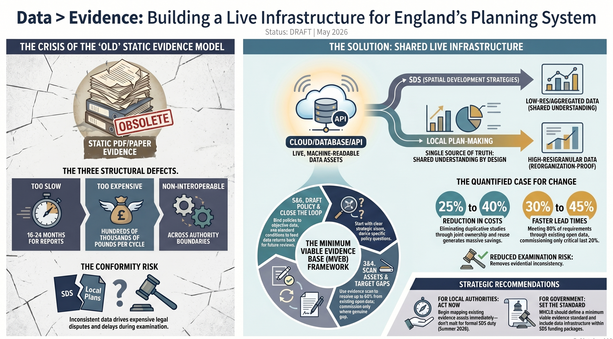
- Reduce evidence commissioning costs by 25% to 40% per plan cycle.
- Accelerate evidence readiness by 30% to 45%.
- Eliminate examination risks caused by inconsistent datasets between planning tiers.
- Create an "investment-ready" environment for public and institutional capital.
1. The Crisis of the Legacy Evidence Model
The existing planning system relies on a commissioned evidence model that has remained unchanged for a generation. This model is currently the primary bottleneck for the new 30-month plan-making aspirations.
1.1 Structural Defects of Commissioned Evidence
Under the current system, local authorities independently commission studies (e.g., Strategic Housing Market Assessments, transport models, viability assessments). This approach suffers from three critical defects:
- Temporal Decay: Evidence is static and begins depreciating the moment it is produced. In a seven-year plan cycle, data is often "stale" before it reaches examination.
- High Cost: A full evidence suite for a medium-sized unitary authority can cost hundreds of thousands of pounds.
- Single-Use Silos: Evidence produced for one authority cannot be easily shared or used by neighbors, even when they share the same housing market or functional economic area.
1.2 Incompatibility with the Two-Tier Architecture
The Planning and Infrastructure Act 2025 requires Local Plans to be in "general conformity" with the SDS. If the SDS and Local Plans use separate, static evidence bases produced at different times with different assumptions, the result is "evidential tension." This tension is typically resolved through expensive and time-consuming disputes during the examination process.
Furthermore, the system faces geographic instability. As devolution arrangements evolve and local government reorganizations occur, static evidence bound to specific administrative boundaries becomes redundant. Only fine-grained, reaggregatable data can survive these shifts.
2. The Proposition: Shared Evidence Infrastructure
The central argument of this briefing is that planning evidence should be treated as a maintained public asset rather than a depreciating consultant product.
2.1 From Data Products to Data Infrastructure
Feature | Legacy "Product" Model | Proposed "Infrastructure" Model |
Format | Static PDFs / Reports | Machine-readable, standardized, open data |
Accessibility | Siloed and proprietary | Openly licensed, accessible via APIs |
Maintenance | Recommissioned every cycle | Maintained continuously |
Scalability | Fixed geographic frame | Reaggregatable to any geography |
Relationship | Evidence supports the plan | Monitoring the plan creates future evidence |
2.2 Shared Understanding by Design
A shared live data infrastructure allows Strategic Planning Authorities (SPAs) and constituent unitary authorities to draw from the same "single source of truth." The SPA aggregates data to a strategic footprint (low-resolution), while the unitary authority disaggregates it for local use (high-resolution). This ensures conformity by design, as both tiers use identical data vintages and methodologies.
3. The Minimum Viable Evidence Base (MVEB) Framework
The MVEB framework is the operational mechanism for translating this policy into practice. It is based on the principle that evidence effort should be proportionate to the policy decision it supports.
The Six-Stage MVEB Process
- Define Strategic Outcomes: Establish three to five specific, examinable objectives (e.g., station-oriented growth).
- Translate into Evidential Questions: Determine exactly what must be demonstrated to withstand examination.
- Scan Existing Assets: Use national and sub-regional datasets (e.g., DfT Connectivity Tool, planning.data.gov.uk). This can resolve approximately 80% of requirements without new commissioning.
- Target Gaps: Commission only for genuine data gaps. Ensure all new commissions specify open data deliverables rather than static reports.
- Draft Policy Tests: Distinguish between "determinative tests" (bound to objective data) and "discretionary matters."
- Use Monitoring to Generate Future Evidence: Require data returns (e.g., build-out rates, biodiversity net gain) to flow back into the SDS data hub, closing the loop for future plan reviews.